Description This is a 2.0-mile grassy road hiking trail located between St. George and Sherwood Lakes. This is an easy trail with very little change in elevation. Although most of the trail is on grassy roads, there are some sections along paved roads. There is limited parking just off St. George Drive on Castlebar Lane.
Driving Directions
From the Peavine Road/Stonehenge Drive stoplight, take Peavine Road towards Crossville. Shortly after passing Food City turn left on to St. George Drive. After 2.25 miles (about one mile after passing Lake St. George) look for the trail sign on the left at the grassy road Castlebar Lane (first left past Amherst Drive). Park on the grassy road.
Most roads are unsigned so follow the trail posts and signs.
Description The trailhead is the Catoosa/Kingsbridge Parking lot on Catoosa Boulevard, but the trail can also be accessed via the Rotherham Drive or North Catoosa parking areas.
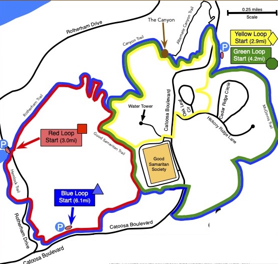
At 6.1 miles, the Blue Loop is the longest hike in Fairfield Glade. It is comprised of four interconnected trails: the Hemlock Trail, the Rotherham Trail, the Canyon Trail, and the McGinnis Trail, along with a short segment of the Good Samaritan Trail.
This is a strenuous hike due to its length and the significant elevation changes along the way. The lowest point is at the end of Lake Dartmoor on Rotherham Drive. The highest point is at the top of the Rotherham Trail near the water tower. In addition there are two significant climbs on the McGinnis Trail.
Driving Directions
Take Peavine Road east and then turn north on to Catoosa Boulevard. After 1.0 mile turn left into the Catoosa/Kingsbridge parking lot marked with Nature Trail sign.
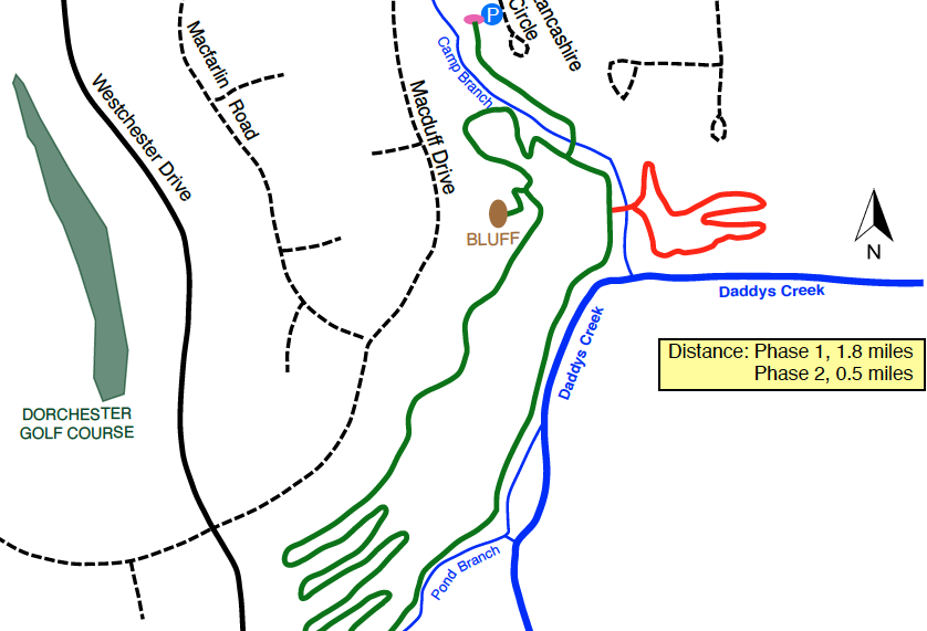
Description This is the newest trail in Fairfield Glade, opened in summer 2025. The main trail is 1.8 miles long, boasting great views, beautiful rock features, huge old trees, SHADE, and water everywhere (after it rains). An additional 0.5-mile loop was opened in fall 2025.
If you hike counter-clockwise, you will ascend a steady climb at the start of the loop to the overlook bluff then descend the switchbacks at the far end of the loop, returning along the creek. If you hike the loop clockwise, you will start with the level trail along the creek, ascend the steep hill using the switchbacks, then descend steadily after the overlook bluff.
Driving Directions
From Peavine Road, turn onto Westchester Dr. Go 3.5 miles, passing the entrance to Dorchester Golf Club. Turn left on Lancashire Rd. (look for the Cascade Trail directional arrow). Proceed 0.3 miles to the third gravel/grass road on the right. Follow the sign to the gravel parking lot on the right. If the lot is full, park on the side of Lancashire Rd, leaving room for traffic to pass.
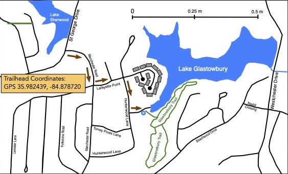
Description This trail begins at the boat ramp at Lake Glastowbury. It is not the easiest trailhead to find but worth the effort! This 1.0 mile trail offers some nice views across the lake but most of the trail is a woodland walk.
Driving Directions From St George Drive take Manchester Road then turn left onto Lafayette Lane. Just before entering the condo complex, turn right onto Hunterwood Lane (Signed to the boat-launch). Turn left to the boatlaunch and park at the trailhead.
Description The Good Samaritan Trail is named for the nearby Good Samaritan facility. The trail forms part of the Red Loop and Green Loop and Blue Loop and Yellow Loop. More information is provided in those trail descriptions.
Description This loop takes you on three trails: the McGinnis Trail, the Good Samaritan Trail and the Canyon Trail. Most of the hike is on dirt trails in the woods but there is a short section on a paved sidewalk. The trail can be hiked in either the clockwise or counter-clockwise direction.
Driving Directions From the junction of Peavine Road and Stonehenge Drive, take Peavine Road east for half a mile and turn left on to Catoosa Boulevard. After 2.8 miles turn into parking area on your right marked with a “Nature Trails” sign.
Description The Hemlock Trail is named for a majestic specimen hemlock tree that hikers will pass along the way. The trail forms part of the Red Loop and Blue Loop and more information is provided in those trail descriptions.
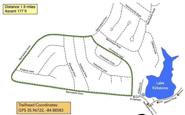
Description This is approximately a 2.0 mile loop hiking trail along gravel roads. The trailhead is at the junction of Marmaduke and Christopher a little way up the hill from the spillway on Lake Kirkstone. The route is marked with yellow stakes and arrows at road junctions. Starting at the trailhead, turn right on to Christopher Lane. At the end of Christopher Lane turn left onto Marmaduke Drive. Follow Marmaduke Drive for about 1.5 miles back the trailhead.
Driving Directions From the junction of Peavine Road and Stonehenge Drive, take Peavine Road east for half a mile and turn right on to Westchester Drive. Follow Westchester Drive for 2.4 miles and turn right onto Malvern Rd. Follow Malvern Rd. for 0.9 miles and turn right on to Marmaduke Drive. Park at the corner of Marmaduke Drive and Oakburn Court.
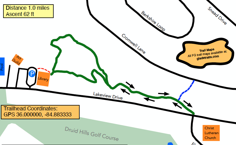
Description This is a “lollipop” trail. Start out behind the library, going either direction along the loop. Travel down the “stick” to Lakeview Drive, then retrace your steps until you reach the loop once more. Complete the loop to return to your car. Extend your hike by either following the signs at Lakeview Drive to reach the Seven Bridges Trail, or by exiting the trail along the blue-blazed path to reach Cromwell Lane.
Driving Directions From the junction of Peavine Road and Stonehenge Drive, take Peavine Road east for 0.5 miles (away from I-40) then turn right on Snead Drive. Travel about 0.5 miles then turn right on Lakeview Drive. Travel about 0.5 miles to the FG Library parking lot on the right.
Trailhead is behind and to the left of the library building, near the restrooms.
Description The McGinnis Trail is now part of the Green Loop which takes you on three trails: the McGinnis Trail, the Good Samaritan Trail and the Canyon Trail. These trails take you on a loop that returns to your car. Most of the hike is on dirt trails in the woods but there is a short section on a paved sidewalk. The trail can be hiked in either the clockwise or counter-clockwise direction.
Driving Directions From the junction of Peavine Road and Stonehenge Drive, take Peavine Road east for half a mile and turn left on to Catoosa Boulevard. After 2.8 miles turn into parking area on your right marked with a “Nature Trails” sign.
Description This is a hiker favorite and annual standard for the Hiking Marathon. The trail was extensively rerouted in 2017 to eliminate grassy roads and a logging road from the route. A 0.6-mile extension was opened in 2023, giving hikers the option to extend or shorten their hike as desired. This trail is a lollipop layout…hike the short stem, then turn left at the first junction to go around the 1.7 mile North Loop before returning along the stem. Alternately, turn right at the first junction, then right again at the second junction to explore the new, shorter 0.9-mile South Loop. Both loops intersect at the creek to create a 2.3-mile outer loop hike (or do a figure-8 for a total of 2.8 miles). However you choose to hike this trail, allow plenty of time to rest or enjoy the scenery.
Driving Directions From the Peavine Road/Stonehenge Drive stoplight, take Peavine going east for half a mile. Turn right onto Westchester drive. After 3.0 miles, just after passing Dorchester Golf Club, turn left onto Windsor Road. Take the second right onto Wimberley Road then immediately turn left onto the gravel road. This road ends at the Overlook parking area and trailhead. After parking your vehicle and enjoying the views from the overlook enter the trail on the left.
Description This is the trailhead for both the Hemlock Trail and the Rotherham Trail. We strongly recommend that you hike this loop in the counter-clockwise direction as this avoids climbing up the very steep Rotherham Trail. Follow the red hike markers.
Proceed along the end of the lake to the trailhead sign for the Hemlock Trail. Follow the trail, past the majestic hemlock tree for which the trail was named, and after half a mile cross Rotherham Drive. After another third of a mile the trail parallels Catoosa Boulevard for a quarter of a mile before turning back into the woods. From there, proceed behind Bluff View Terrace and climb upwards for nearly half a mile to the Good Samaritan Trail. Turn left and follow the trail behind the Good Samaritan assisted living facility for a half a mile until you reach the intersection with the Rotherham Trail.
Turn left onto the Rotherham Trail and follow the trail as it descends steeply into the valley. After half a mile the trail turns left along the creek and levels out for an easy walk for the last half-mile to the Rotherham Drive parking lot where the hike started.
Driving Directions From the junction of Peavine Road and Stonehenge Drive, take Peavine Road east for half a mile and turn left on to Catoosa Boulevard. After about 1.2 miles turn left on to Rotherham Drive. Drive down the steep hill and after 0.6 miles you will come to the parking lot on the left at the end of Lake Dartmoor.
Note: There is alternative parking available on Catoosa Boulevard at the junction with Kingsbridge Lane (Blue Hike Parking).
The Rotherham Trail is named for the nearby Rotherham Drive. The trail forms part of the Red Loop and Blue Loop and more information is provided in those trail descriptions.
Driving Directions
From the junction of Peavine Road and Stonehenge Drive, take Peavine Road east for half a mile and turn left on to Catoosa Boulevard. After about 1.2 miles turn left on to Rotherham Drive. Drive down the steep hill and after 0.6 miles you will come to the parking lot on the left at the end of Lake Dartmoor.
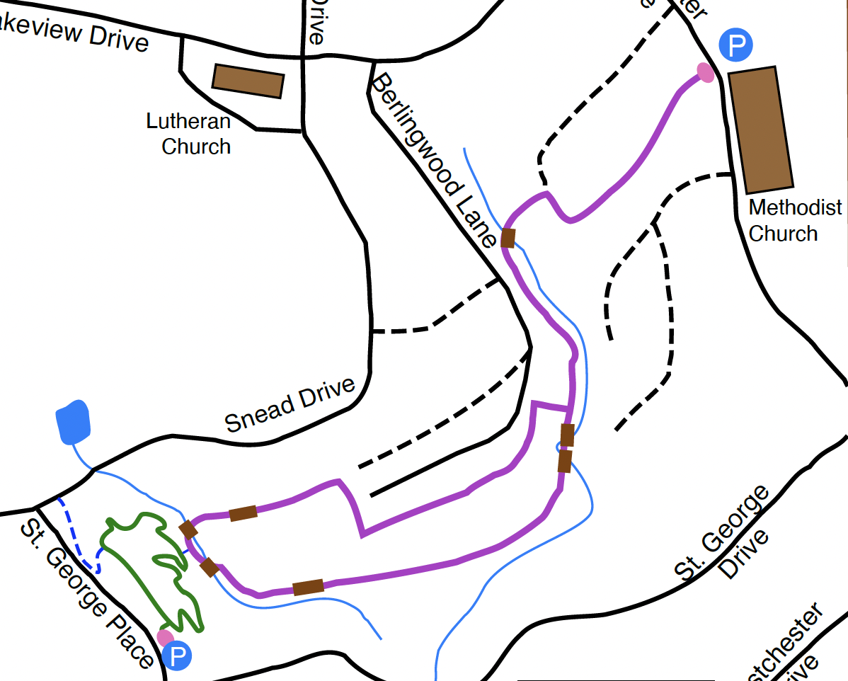
Description This trail begins at the Methodist Church on Westchester Drive. It is a pleasant walk through the woods by a number of streams crossed by seven bridges. The trail is a lollipop configuration consisting of a half-mile stem and then a one-mile loop…return to the trailhead along the stem. You can extend your hike by including the 0.5 mile St. George Trail loop. The short connector between the two trails is approximately halfway around the loop.
Driving Directions From the junction of Peavine Road and Stonehenge Drive head east along Peavine Road for 0.5 miles. Turn right on to Westchester. Head south for 0.7 miles and pull into the first parking lot of the Methodist Church where trail parking is permitted. Cross the road to the trailhead.
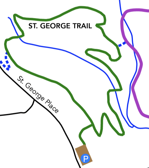
Description This short loop trail provides an extension to the popular Seven Bridges Trail. Neighborhood residents can walk to and access the trail via Snead Drive, while visitors can park at the trailhead on St. George Place.
Driving Directions From Crossvillle, take Peavine Rd. going east. Turn right onto Westchester Dr. Continue 0.9 miles and turn right onto St. George Drive. In 0.2 miles, turn right onto St. George Place. The parking lot is on your right.
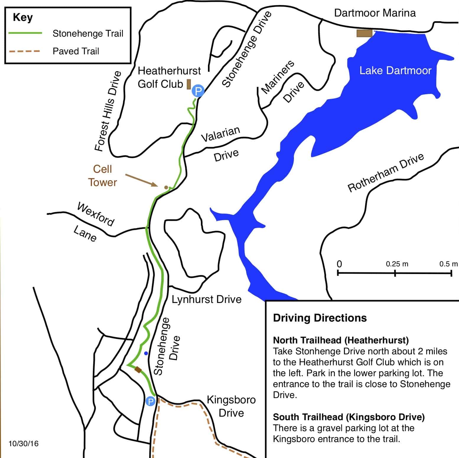
Description This is a 1.5-mile linear trail so the round-trip distance is 3.0 miles. The half-way point is the Heatherhurst golf club. The highest point of the trail is around the Lynhurst Drive area. Consequently it is a steady uphill climb from either end of the trail.
Driving Directions From the junction of Peavine Road and Stonehenge Drive, head north on Stonehenge Drive for 0.9 mile to the trail-head parking lot, on the left, at the corner of Kingsboro Drive.
Description The trailhead is in the parking lot of the Dorchester Golf Club. The trail starts by carefully crossing Westchester Drive onto Thornhill Lane. Most of the trail is on gravel/grassy roads that are unsigned so follow the trail posts and signs. It is worth taking a short detour on the dam of Lake Malvern to admire the view. The trail consists of flat roads. The biggest hazard is some deep ruts that fill with mud and water after heavy rains.
Driving Directions From the Peavine Road and Stonehenge Drive stoplight, take Peavine Road east. After 0.5 miles turn right on to Westchester Drive. After 2.0 miles turn right into the Dorchester Golf Club parking lot. Park away from the clubhouse, near Westchester Drive at the trail-head
Description This hike takes you through the Fairfield Glade canyon. The trail was extensively rerouted a few years ago due to the construction of new homes in the area. The new route is much more hiker-friendly than the old route and we are sure you will enjoy it.
Driving Directions From the junction of Peavine Road and Stonehenge Drive, take Peavine Road east for half a mile and turn left on to Catoosa Boulevard. After 2.8 miles turn into parking area on your right marked with a “Nature Trails” sign.
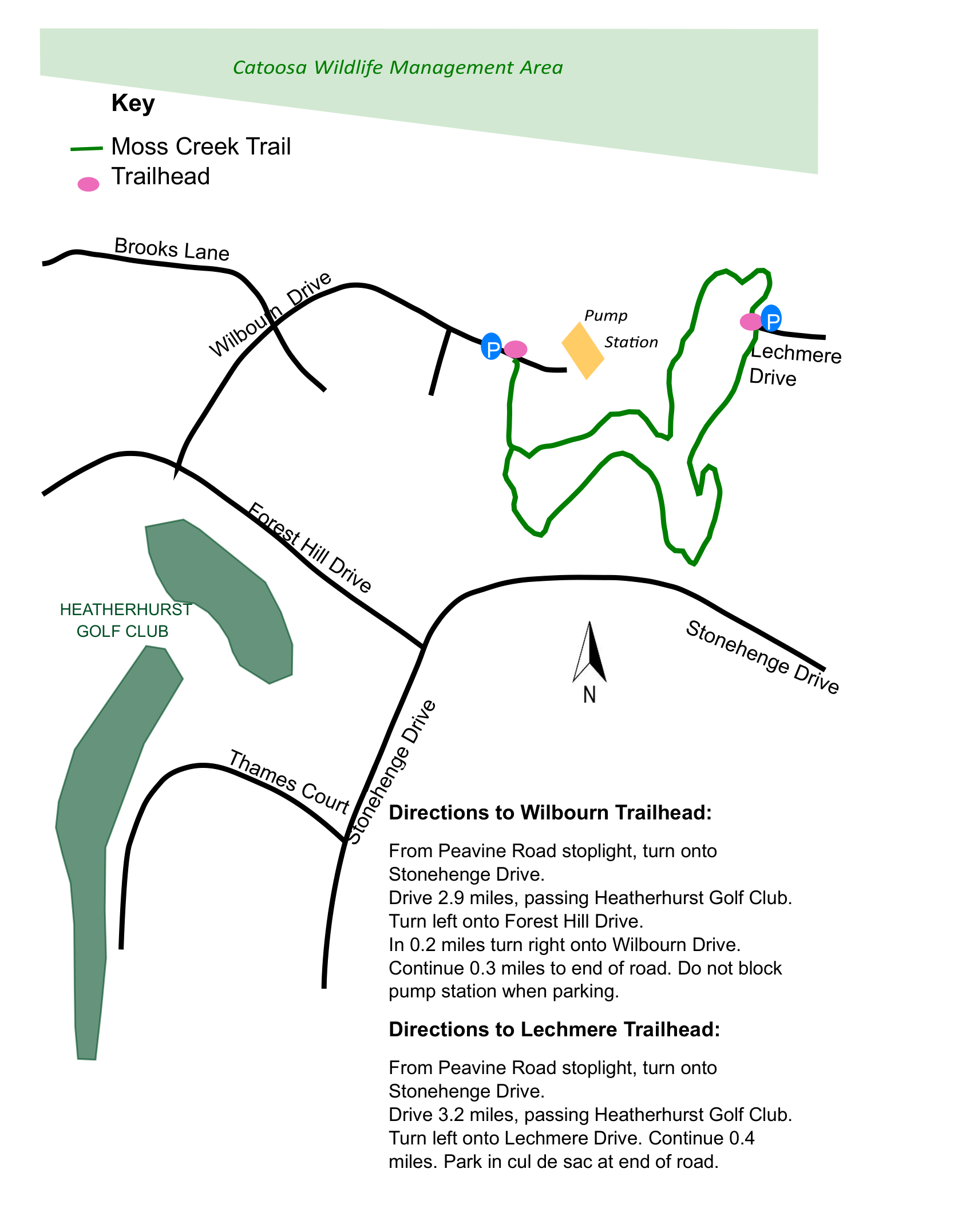
Description This hike takes you through a half mile hike that is easy to navigate. While being near neighborhoods, the natural trail feels like being deep in a forest. There are two convenient trail head entrances. When using the Wilbourn entrance, please be sure to part well away from the pump station at the end of the road.
Driving Directions Wilbourn Drive Trailhead: From Peavine Road stoplight, turn onto Stonehenge and drive 2.9 miles, turn left on Forest Hill Drive. In 0.2 miles turn right onto Wilbourn Drive. Park near the trail entrance in 0.3 miles.
Lechmere Trailhead: From Peavine Road stoplight, turn onto Stonehenge and drive 3.2 miles, then left onto Lechmere Drive. Continue 0.4 miles and park in the cul de sac at the end of the road.